Friday, September 15, 2017

Route: Kyes Peak - South Ridge (Central Cascades)

Mountain Information:

Driving Directions:

  • Trailhead: 
    • Address: NF-63, Gold Bar, WA 98251
    • Due to ongoing resource damage there is no overnight camping allowed at Blanca Lake. Campfires are also prohibited at lake.Road damage has made the trail head inaccessible. Temporary trail head at 63 junction. Federal Recreation Pass required to park.
    • The "new" trailhead is obvious, it is right where NF-63 coming from the west (the Index-Galena Road) hits NF-65 coming from the east (where you arrive from). The continuation of NF-63 north to the trailhead is blocked right there (although the actual washouts are much closer to the old trailhead), so you park near that intersection and hike up NF-63.
    • The 2 mile hike to the old trailhead is easy. Note that the toilet at the old trailhead is locked.

NF-63 to Old Trailhead Closed
Parking Sign

Junction of NF-65 and NF-63


Route Information: South Ridge


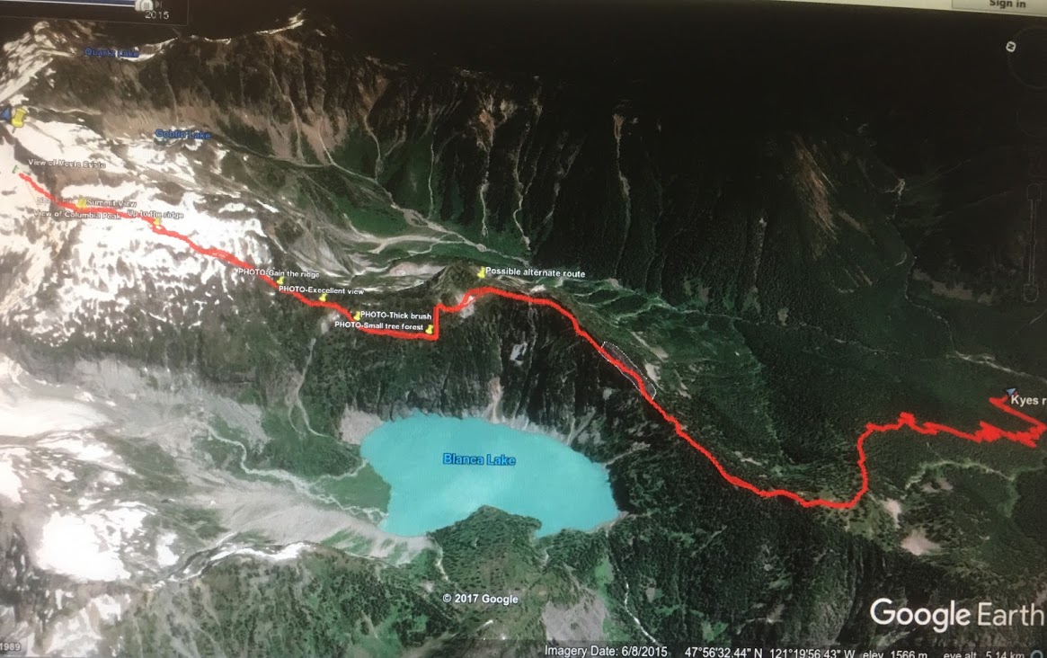
Existing GPS Track

Path with Annotations
Route Markers and Summary

FR 63 to old Blanca Lake Trailhead
Virgin Lake Split
Talus Bypass Point 5845
Saddle to South Face
Pass to Summit
Summit Traverse

  • Route Photos from trip reports:
Virgin Lake

Starting Point

Route along Point 5845
Ridge Saddle

 Kyes Peak South Face
Route to Approach Pass
Boulder to Pass
Summit Traverse

Ascend the Pass

Shark Fin on the Pass
Around about on Pass
Summit Ridge

Approach Summit Block
Summit Block

Scramble Path on Summit
Water Source
Bivy/Camping Site close to Summit Block

Columbia Glacier and Kyes Peak from Cloumbia Peak

Blanca Lake from Ridge

  • Approach & Ascend from Mountaineers: 
    • Take Blanca Lake Trail to Virgin Lake (4,600 ft), a great place to camp if you make this a multi-day trip. From Virgin Lake, take the south ridge going northeast. You may have to stay on the east side to traverse the ridge.  The trail levels out at 5,300 ft. Head onto the west side of the ridge at 5,845 ft, and then up steep slopes, avoiding cliff bands.  Cross a boulder field at 6,300 ft and then aim for a gap at Point 7026. Some Class 4 scrambling to the summit.

Misc 

  • Notes
    • Kyes peak is the highest summit in the Monte Cristo Group and is very isolated from civilization. When the weather is good this peak offers views of the many famous peaks in Washington including Sloan Peak, Mount Pugh, Baker, Rainier, Glacier Peak and many more. This peak is pretty much in the middle of the Cascade Range.
    • Other high peaks in the Monte Cristo group include Columbia Peak (7,172ft), Monte Cristo Peak (7,136ft), and Cadet Peak (7,186ft).
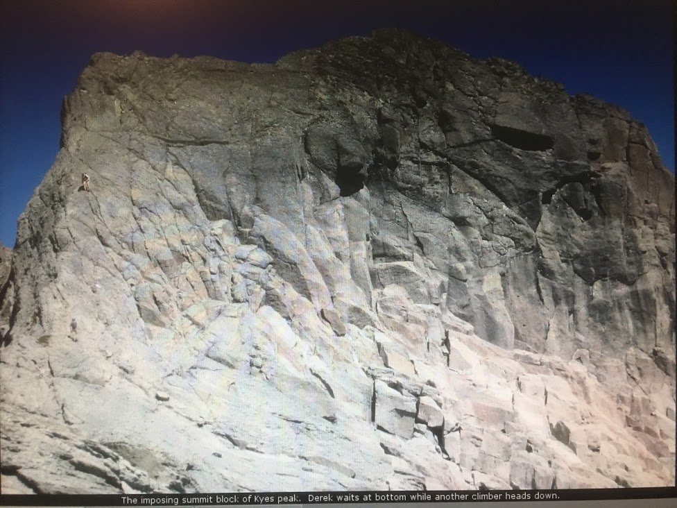
    • From a distance, the summit block looks very formidable, but as it turns out, it is quite easy. There are a number of seams in the rock that make for excellent footholds as you ascend. These were followed up. The only challenge to this part of the scramble is the loose rock everywhere.
    • Based on one Peakbagger report
      • First part of climber's trail: easy hiking but somewhat overgrown down low. Highlight is a pleasant small meadow.
      • Overgrown ledges: I found this to be the worst part in some ways. The faint path is easy to lose and it traverses and climbs up some rocky fins and ledges. I could not find a route that did not involve ugly class 3 bushwhacking, but one might exist.
      • Trail on pleasant ridge: past the overgrown ledges, the trail is pretty nice for a while, on or near the crest, mostly flat. Nice views.
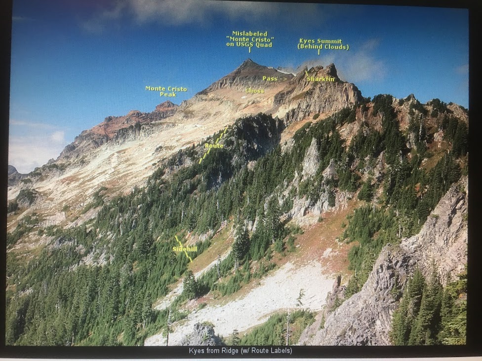
      • The trail drops down to the west and sidehills to avoid Peak 5845. The heather is slippery with difficult footing even when dry, and there are glades of closely spaced evergreens to bushwhack through. You can stay high or low to get different mixtures of these. A small boulder field down low offers a tempting way to avoid a little of the sidehilling, but not much.
      • The Steep Ridge: From the col at 5400', a faint trail switchbacks relentlessly uphill, partly in forest, party in open heather clearings. The footing is OK, but there are countless variations. Up top it gets steep and a bit rocky before finally cutting left to descend a rocky staircase ramp to the talus basin below, in a section of white blocks (marked with cairns). 
      • The Talus Basin: A huge, sloping, open, rocky area. In early season probably mostly snow, in September a mix of huge blocks, ball-bearing scree, and everything in between. Angle uphill, past a small lake, towards a notch in the skyline ridge.
      • The South Ridge: The bedrock of breccia is huge, solid, rounded blobs offering good friction, but the scree lying about is miserable loose ball-bearing gravel that can be very slippery. Follow ledges and the crest, trying to avoid the gravel the best you can. The final push to the summit block is easy, on clean, flat, glacier-scoured rock (or snow in early season).
      • The Summit Block: As you approach it is foreshortened and looks intimidating, but it is easily climbed directly using seams in the pillowy breccia. Just don't step on any gravel. Near the top a ledge leads right directly the airy summit. Downclimbing is definitely trickier, but it goes OK with care.
    • (From SummitPost) It is a rocky point (Peak 5845) on the ridge with cliff bands and potentially dangerous terrain. There was bootpath going up Peak 5845, but people usually drop down to the west and sidehill to avoid gain/lose elevation. This spot is easy to find any time of the year because it is mostly flat when you get there. Be warned, in later season this is where the blueberry bushes start up which often times is slippery making travel a little bit more tedious. So now traverse the mountain going slightly up hill towards your right until you think your a little ways beyond Point 5845. Then starting heading almost directly up, if you encounter a cliff band, you have to keep traversing.
    • Depending on where you end up you may get either onto the ridge again or at the notch which is on the ridge. Either one is fine, but the ridge is probably the better option. You may get lucky and find a rigged trail that switchbacks up the mountain, if not, no big deal. But you do want to make sure you don't end up on any unnecessary terrain. There should not be any terrain beyond class 2 until you get to the summit block.
    • Once you start getting glimpses of Kyes Peak and of the boulder field, you should head towards it. But do keep in mind there are some cliffs below between you and the boulder field which there is a nice traverse "pathway" to the right which is a series of mini scramble sections down the the boulder field.
    • Even in late season much of the boulder field is covered in snow, which depending on snow conditions it might be time to take out the ice axe if you brought one, I personally was fine without one but the snow was soft. Head towards the false summit to the north, but eventually you want to curve to the right. You will see a section I call "The Gap" which is a small notch in the ridge between two high points.
    • Once you scramble up to the gap you are back on the ridge again which doesn't look very ridge like at this point. Now go towards the round about and then to the right of it which takes you to a permanent snow field. If you like snow, take the snow field towards the summit block. If you like rock, take the ridge to your left which is nice and gentile although with a few ups and downs.
    • The summit is the one on the right which of course is the one farther away. But at least it's a cats walk from here. Once you get to the summit block it is considered class 2, perhaps class 3 depending on how you rate a route. I will admit though that one should be cautious here because there is some loose pebbles and such on the rock making it a little more tricky. But for most mountaineers it won't be much of a problem. The summit pyramid is not as bad as it looks. Look for the crack that has nice foot holds which takes you about 20 feet from the summit. The last 20 or so feet carefully traverse over to the summit. From here you are rewarded with a great view of the area.
    • To avoid bushwhacking on the south ridge, people could descent via the Columbia Glacier route or Blanca Lake NW side.
    • There are bivy sites close to summit block
    • This mountain can be climbed year round, but is recommended between the months of June through October. Early summer is probably best because of all the blue berry bushes you have to travel over in later season. But the later months tend to have better weather. So it's debatable which you prefer and it also depends on the weather that year.

Wednesday, August 30, 2017

Route: Black Peak - South Ridge (North Cascades)

Mountain Information:

Driving Directions:


Route Information: South Ridge


  • Approach from SummitPost: 
    • Start at the Rainy Pass trailhead off Highway 20. Note this road is closed in winter and typically doesn't open until late April or early May. Hike up the Lake Ann Trail from the Rainy Pass parking area for about a mile to a signed junction. Take the right fork uphill (Heather Pass/Maple Pass Trail) and proceed up the nice trail towards Heather Pass. The left fork heads down to Lake Ann. There is an obvious short fork on the right leading a few feet to the small meadow at Heather Pass which is about 2 miles from the trailhead. Now the peak and the route can be seen. Continue along the climber's path for 1 mile across two talus fields to Lewis Lake, which can be seen the entire traverse. This traverse descends about 400 feet and it is best to stay to the lower end of the talus slopes further right where the rocks are more stable and the trail more defined. Continue around the left (south) side of the lake, staying on the path. Eventually the path takes a sharp right up a moraine in a larch grove which displays spectacular foliage in late September. Continue on the path to Wing Lake which is about 2.5 miles from Heather Pass. There is good camping here at the lake. Although the climb can (and often is) done in a day, an overnight trip is highly recommended to get the benefit of good lighting and ambiance in this exceptional area.
  • Ascend from SummitPost: 
    • From the lake, hike around its right (north) side and aim for the obvious talus/snow gully heading to the couloir to the left (south) of Black Peak. After working up this for awhile, work your way up the slope angling right from the gully to avoid the cliffs just below the actual south col. This section is some of the loosest ball bearing rock I have ever been on in Washington, and to the inexperienced it can be scary. Just place your feet carefully. There are some small bivy sites where the route meets the south ridge at just below 8000 feet. Once you crest the ridge you see your first views of Mount Goode and its classic NE buttress.
    • From here, ascend the ridge following cairns when possible until forced into a gully just on the left (west) side of the ridge. Follow this considerably loose gully for quite a ways and stay right when the gully forks. Most of the way up you should be just to the west of the ridge crest. Once at the top of the gully re-gain the crest and ascent a short ways to the base of the false summit. Cut right and traverse a ledge at the base of the summit area along its south side all the way until you get to the east edge of the summit area. Do not try and climb up too soon, this traverse lasts longer than one may think it would. Wait until the far east side and ascend a class 3 section which leads up to the summit. Views in all directions are absolutely fantastic with Goode Mountain and Storm King to the west, Baker and Shuksan to the north and much of the Glacier Peak Wilderness to the south.
  •  Descend from SummitPost: 
    • Descend the way you came. Be very careful to avoid knocking rocks down on people below you. Most of this route is loose especially the descent off the south col where even the best of us may slip. Keep in mind you will have to re-climb the 400 feet from Lewis Lake to Heather Pass on your way back. 

Misc 

  • Notes: 
    • A Grade II climb with class 4 rock and snow up to 30° to the summit of one of the higher non-volcanic peaks in Washington State. The approach passes multiple lakes where established camp sites can be found. The route has loose rock in many places therefore care must be taken to reduce the risk of party-inflicted rockfall.
    • The summit sits on the border between North Cascades National Park and the Okanagan National Forest. Most will chose to camp east of the peak and no permit is required. Camping in the National Park requires a permit, which can be obtained in either Winthrop or Marblemount, depending from which direction you are coming.
    • Camping is possible at Lewis and Wing Lakes, with Wing Lake having by far the better spots. There is fee camping at the trail head.
    • Since this peak is at Rainy Pass, Marblemount weather is likely to be more pertinent than east side weather.
    • Hike east around Wing Lake, up the moraine and onto a gentle permanent snowfield to an obvious col in the south ridge. A broad gully on the west side leads to the final summit blocks. About 150 below the false summit, traverse east at one of several notches below the summit. Any number of Class 3 ways can be found to the summit.
    • From Rainy Pass, follow the Lake Ann side of the Lake Ann/Rainy Lake loop trail. When almost at the top of the ridge (Heather Pass on the map), the main trail swings left and a line of rocks are meant to keep hikers on the main trail. This is where the trail to Wing Lake leaves. Drop about 200 feet on a long traverse above Lewis Lake (there is a well defined trail), crossing 2 prominent rock slides. Bypass the lake on the south and continue towards the prominent morraine. Stay north below the morraine and hike through a series of larch meadows to Wing Lake. There are good camping spots near the lake.
    • Be sure to bring an ice axe, crampons, sturdy boots, and a helmet. Other than that, just basic hiking gear should be brought, with a little extra warm clothing because of the exposure and elevation. Plan on at least most of a day for this route. If you're fast and go solo it can be done in half a day but take time to enjoy the scenery. If camping, the best place to camp is in the larch groves just below Wing Lake. There are also a few good spots at Wing Lake or you can camp at one of the bivy sites at the south col. Camping at Lewis Lake was almost non existent. 
    • Latest update from NPS: The upper south face gullies are completely snow free and are marked very well with cairns for route finding. The broad snow gully to approach the upper section is still mostly snow, with some steep loose talus at the top. This may be the most unpleasant part of the route. A lovely climb over all.  
    • Black Peak could be climbed via the NE Ridge route. First 3rd of the climb is chossy and crappy. Rock quality gets better as you go. 

Tuesday, August 15, 2017

Route: Mount Daniel - SE Ridge (Alpiine Lakes Wilderness)

Mountain Information:

Driving Directions:

  • Trailhead: Cathedral Rock Trailhead
  • Co-ordinates: 47.54421,-121.09686
  • Address: NF-153, Ronald, WA 98940
  • Elevation:  3,350 ft
  • Pass:  Northwest Forest Pass
  • Directions 
    • WTA: "From Seattle, take I-90 east to exit 80. At the end of the exit ramp, turn left onto Bullfrog Road to cross over the highway. At the second roundabout, continue onto WA-903 North to Salmon La Sac. Continue on WA-903 North passing through the towns of Roslyn and Ronald until the road becomes Salmon la Sac Road. A few yards past the Ranger Station, keep right on a rough dirt road (Forest Road 4330). Drive approximately 12 miles to the end of the road and the Cathedral Rock trailhead."
  • I-90 Road Condition:   

Route Information: Southeast Ridge

  • Gain: 5,200 ft
  • Round Trip:  16 miles
  • Type:  scramble
  • Difficulty: Strenuous 5, Technical 4
  • Season: June, July, August, September
  • Ascent: "Follow the Deep Lake trail 4.5 miles to Cathedral Pass (5,500 ft). As you descend towards Deep Lake, there is a good trail leading towards Peggys Pond at the end of a switchback. The path traverses to the lake. From the lake there is a path most of the way to Mount Daniel after the snow melts. The path is along the southeast ridge that is between Circle Lake and the permanent snowfield shown on the USGS map. Follow the ridge to the saddle below the east summit (7,899 ft). The east summit is an enjoyable scramble along its south ridge if time permits. Traverse from this saddle to the saddle between the east and middle summits. From here walk up the talus slope to the middle summit, and then follow the southeast ridge of the west summit to the base of the summit block. Scramble along the south side to reach the summit."
  • Source: https://www.mountaineers.org/explore/routes-places/mount-daniel
  • Existing tracks for approach: 
  • Caltopo Route: https://caltopo.com/m/MRQN

Misc 

  • Videos: 
  • Other Links: 
  • Notes: 
    • At 7960 feet, Mount Daniel is the highest point in both King County, the county of Seattle, and Kittitas County.
    • Daniel is a complex glaciated massif with five main summits along its east-west trending spine.  They are known as East Peak (7,899 feet), Middle Summit (7,959 feet), West Summit (7960+ feet, true summit), West Pyramid (7880+ feet), and Northwest Peak (7,686 feet).
    • The Lynch Glacier flanks the mountain on the north and drains into the East Fork Foss River.  It is the largest glacier on the mountain, but has experienced rapid melt in recent years draining into Pea Soup Lake. 
    • The Daniel Glacier is located on the northeast side between Middle Summit and East Peak and its runoff drains into the Cle Elum River.
    • Hyas Creek Glacier, which may be turning into more of a permanent snowfield, is east of East Peak and also drains into the Cle Elum River.  
    • Mount Daniel is surrounded by lakes.  The largest of these are Marmot and Jade Lakes, to the north, Hyas Lake to the east and Spade, Circle, Venus, and Deep Lakes to the south.
    • Cascade Alpine Guide V1 described the SE ridge route as follows: "From the saddle area adjacent to Peggys Pond, climb W up talus and neve, keeping right of a bedrock hump in the basin center. Head upslope over the Hyas Creek Glacier toward the East Peak, or follow the gentle SE ridge to left of the upper basin (this easy ridge has a small rock outcrop to bypass or cross). Skirt S of the summit of East Peak on loose talus (keep closely under top) to the 7,600-ft saddle between it and the middle summit. Follow the gentle crest above the Daniel Glacier to the NW. Then either climb the middle summit or follow plateau just to its S to reach the true (western) summit. The East Peak is merely a hike-scramble from the high point on the SE ridge, or from the Middle-East saddle."
    • In general stay to the left of the ridge crest and avoid the snowfield below, climbing several sections of steep rock in order to pass Point 7662. There is a choice here between a rock slab with a bad runout on the right, or a steep snow slope (right up the middle).
    • The terrain between East and West summit is fairly straightforward - traverse across the snow to reach the saddle (excellent views here) and climb to the rocky terrain just beneath the summit. The true summit is the highest of the rock spires (class 3).
    • Mount Daniel could be climbed from Lynch Glacier. Cascade Alpine Guide V1 stated: "The approach could be made from Marmot Lake and Lynch Draw. Recent recession of the Lynch Glacier has resulted in an enlarged Pea Soup Lake, whose waters now loop back to the cliffs. Unless this situation changes, this is not a practical summer route, especially from an eastern approach."
    • Mount Daniel could also be climbed from Daniel Glacier.
    • Some people climb the Cathedral rock along the way as described in this report.
    • The footing on the traverse path could be a little loose some places, just watch your step and follow the cairns.
    • This scramble can be done in a day or in two days with a camp near Peggy's Pond, but the mosquitoes can be ferocious in late July and early August.
    • Existing GPS tracks: https://caltopo.com/m/1NE4

Monday, August 7, 2017

Route: The Tooth South Face (I-90 Snoqualmie Pass)

Mountain Information:

Driving Directions:

Route Information: South Face

Misc 

Friday, August 4, 2017

Route: Vesper Peak (Mountain Loop Highway)

Mountain Information:

Driving Directions:

  • Trailhead: Sunrise Mine Trailhead
  • Co-ordinates: 48.0295755,-121.5085599
  • Address: Sunrise Mine Trailhead, NF-4065, Granite Falls, WA 98252
  • Elevation:  2100 ft
  • Pass:  Northwest Forest Pass
  • Directions 
    • SummitPost: "From Seattle take I-5 North to Exit 194. Follow Highway 2 East for 2.3 miles, stay in left lane, go to Lake Stevens Highway 204 East, in 2.2 miles take left (north) on Highway 9 to Lake Stevens, in 1.7 miles take right (east) on Highway 92 to Granite Falls, in 8.4 miles turn left (north) to Mountain Loop Highway. Follow for about 30 miles to the Sunrise Mine Road on the right. Road dead ends in about 1 mile where parking is limited to one side of the road. Leave room for others to turn around."
  • Weather forecast
  • Avalanche danger forecast:  

Route Information: Headless Pass

Misc