Mountain Information:
- Name: Kyes Peak
- Region: Central Cascades
- Summit Elevation: 7284 ft / 2218 m
- SummitPost:
- Peakbagger:
- WTA Link:
- Mountaineers Link:
- Mt Baker-Snoqualmie National Forest:
Driving Directions:
- Trailhead:
- Address: NF-63, Gold Bar, WA 98251
- Due to ongoing resource damage there is no overnight camping allowed at Blanca Lake. Campfires are also prohibited at lake.Road damage has made the trail head inaccessible. Temporary trail head at 63 junction. Federal Recreation Pass required to park.
- The "new" trailhead is obvious, it is right where NF-63 coming from the west (the Index-Galena Road) hits NF-65 coming from the east (where you arrive from). The continuation of NF-63 north to the trailhead is blocked right there (although the actual washouts are much closer to the old trailhead), so you park near that intersection and hike up NF-63.
- The 2 mile hike to the old trailhead is easy. Note that the toilet at the old trailhead is locked.
 |
| NF-63 to Old Trailhead Closed |
 |
| Parking Sign |
 |
| Junction of NF-65 and NF-63 |
- Elevation: 1,800 ft
- Pass: Northwest Forest Pass
- Directions:
- WTA:
"Take US Hwy 2 east from Monroe to just past the town of Skykomish. Turn left on to FR 65, more clearly marked as Beckler River Road and drive 12.5 miles on this road, passing the Beckler River Campground just after the pavement turns to gravel. After driving 12.5 miles, you arrive at Jack Pass, a 5 way junction. Take the second left. After driving 2.3 miles descending from Jack Pass, arrive at a junction with FR 63 and the private Garland Mineral Springs Road."
- Food
- Road condition
- Weather forecast
- Avalanche danger forecast:
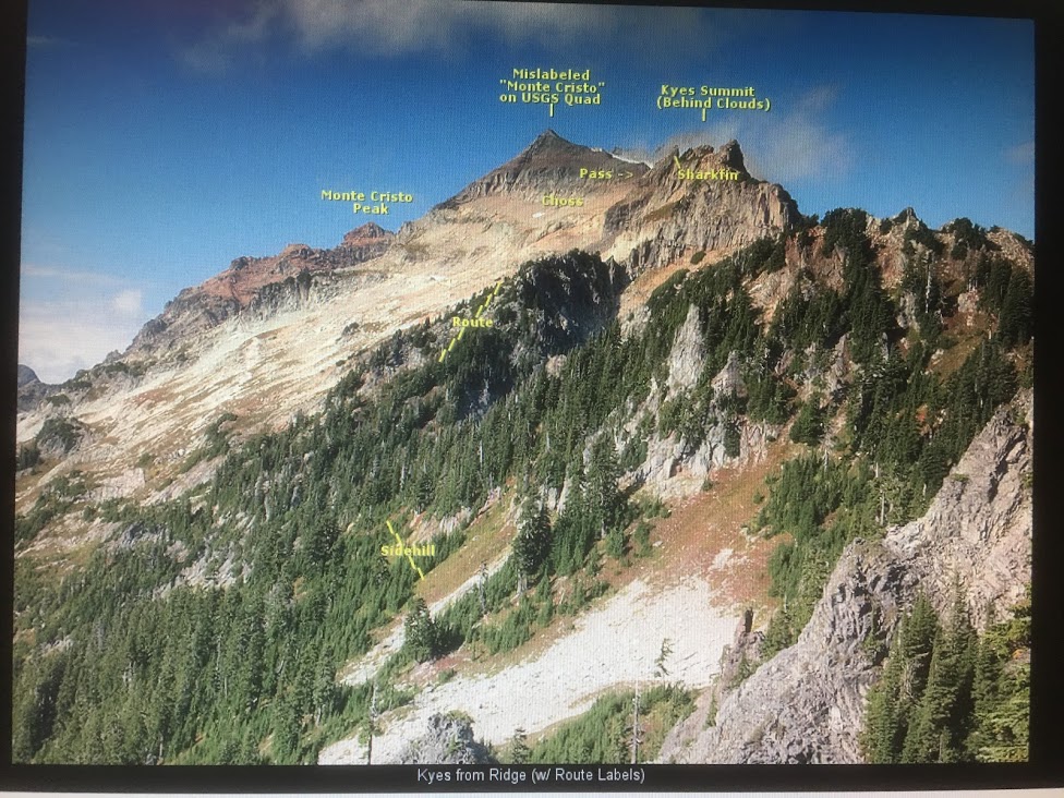
Route Information: South Ridge
 |
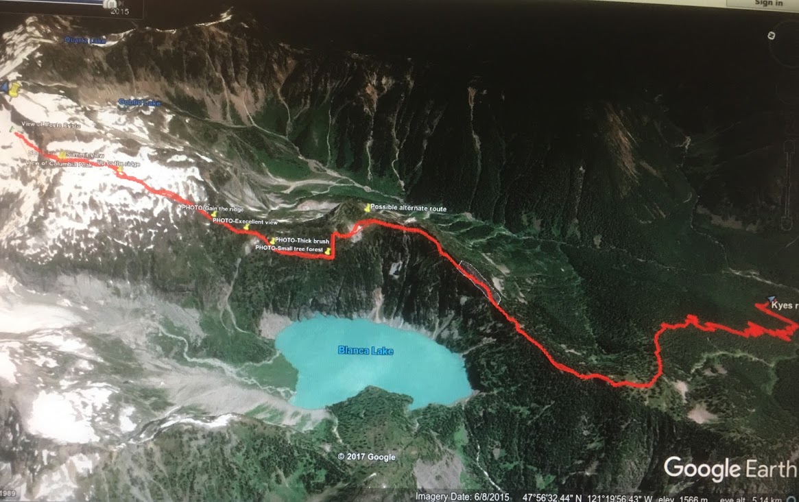
| Existing GPS Track |
 |
| Path with Annotations |
 |
| Route Markers and Summary |
 |
| FR 63 to old Blanca Lake Trailhead |
 |
| Virgin Lake Split |
 |
| Talus Bypass Point 5845 |
 |
| Saddle to South Face |
 |
| Pass to Summit |
 |
| Summit Traverse |
- Route Photos from trip reports:
 |
| Virgin Lake |
 |
| Starting Point |
 |
| Route along Point 5845 |
 |
Ridge Saddle
Kyes Peak South Face |
 |
| Route to Approach Pass |
 |
| Boulder to Pass |
 |
Summit Traverse
 |
| Ascend the Pass |
|
 |
| Shark Fin on the Pass |
 |
Around about on Pass
 |
| Summit Ridge |
 |
| Approach Summit Block |
|
|
 |
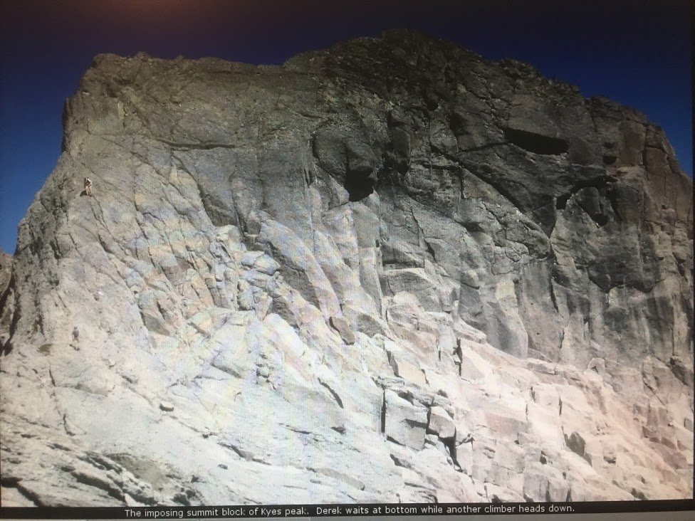
Summit Block
 |
| Scramble Path on Summit |
|
 |
| Water Source |
Bivy/Camping Site close to Summit Block
 |
| Columbia Glacier and Kyes Peak from Cloumbia Peak |
 |
| Blanca Lake from Ridge |
- Approach & Ascend from Mountaineers:
- Take Blanca Lake Trail to Virgin Lake (4,600 ft), a great place to camp if you make this a multi-day trip. From Virgin Lake, take the south ridge going northeast. You may have to stay on the east side to traverse the ridge. The trail levels out at 5,300 ft. Head onto the west side of the ridge at 5,845 ft, and then up steep slopes, avoiding cliff bands. Cross a boulder field at 6,300 ft and then aim for a gap at Point 7026. Some Class 4 scrambling to the summit.
Misc
- Videos:
- Trip Reports:
- WTA trip reports
- CascadeClimbers trip reports
- Nwhikers.net trip reports
- Notes:
- Kyes peak is the highest summit in the Monte Cristo Group and is very
isolated from civilization. When the weather is good this peak offers
views of the many famous peaks in Washington including Sloan Peak, Mount
Pugh, Baker, Rainier, Glacier Peak and many more. This peak is pretty
much in the middle of the Cascade Range.
- Other high peaks in the Monte Cristo group include Columbia Peak (7,172ft), Monte Cristo Peak (7,136ft), and Cadet Peak (7,186ft).
- From a distance, the summit block looks very formidable, but as it turns out, it is quite easy. There are a number of seams in the rock that make for excellent footholds as you ascend. These were followed up. The only challenge to this part of the scramble is the loose rock everywhere.
- Based on one Peakbagger report:
- First part of climber's trail: easy hiking but somewhat overgrown down low. Highlight is a pleasant small meadow.
- Overgrown ledges: I found this to be the worst part in some ways. The faint path is easy to lose and it traverses and climbs up some rocky fins and ledges. I could not find a route that did not involve ugly class 3 bushwhacking, but one might exist.
- Trail on pleasant ridge: past the overgrown ledges, the trail is pretty nice for a while, on or near the crest, mostly flat. Nice views.
- The trail drops down to the west and sidehills to avoid Peak 5845. The heather is slippery with difficult footing even when dry, and there are glades of closely spaced evergreens to bushwhack through. You can stay high or low to get different mixtures of these. A small boulder field down low offers a tempting way to avoid a little of the sidehilling, but not much.
- The Steep Ridge: From the col at 5400', a faint trail switchbacks relentlessly uphill, partly in forest, party in open heather clearings. The footing is OK, but there are countless variations. Up top it gets steep and a bit rocky before finally cutting left to descend a rocky staircase ramp to the talus basin below, in a section of white blocks (marked with cairns).
- The Talus Basin: A huge, sloping, open, rocky area. In early season probably mostly snow, in September a mix of huge blocks, ball-bearing scree, and everything in between. Angle uphill, past a small lake, towards a notch in the skyline ridge.
- The South Ridge: The bedrock of breccia is huge, solid, rounded blobs offering good friction, but the scree lying about is miserable loose ball-bearing gravel that can be very slippery. Follow ledges and the crest, trying to avoid the gravel the best you can. The final push to the summit block is easy, on clean, flat, glacier-scoured rock (or snow in early season).
- The Summit Block: As you approach it is foreshortened and looks intimidating, but it is easily climbed directly using seams in the pillowy breccia. Just don't step on any gravel. Near the top a ledge leads right directly the airy summit. Downclimbing is definitely trickier, but it goes OK with care.
- (From SummitPost) It is a rocky point (Peak 5845) on the ridge with cliff bands and potentially dangerous terrain. There was bootpath going up Peak 5845, but people usually drop down to the west and sidehill to avoid gain/lose elevation. This spot is easy to find any time of the year because it is mostly flat
when you get there. Be warned, in later season this is where the
blueberry bushes start up which often times is slippery making travel a
little bit more tedious. So now traverse the mountain going slightly up
hill towards your right until you think your a little ways beyond Point
5845. Then starting heading almost directly up, if you encounter a cliff
band, you have to keep traversing.
- Depending on where you end up you may get either onto the ridge again or
at the notch which is on the ridge. Either one is fine, but the ridge
is probably the better option. You may get lucky and find a rigged trail
that switchbacks up the mountain, if not, no big deal. But you do want
to make sure you don't end up on any unnecessary terrain. There should
not be any terrain beyond class 2 until you get to the summit block.
- Once you start getting glimpses of Kyes Peak and of the boulder field,
you should head towards it. But do keep in mind there are some cliffs
below between you and the boulder field which there is a nice traverse
"pathway" to the right which is a series of mini scramble sections down
the the boulder field.
- Even in late season much of the boulder field is covered in snow, which
depending on snow conditions it might be time to take out the ice axe if
you brought one, I personally was fine without one but the snow was
soft. Head towards the false summit to the north, but eventually you
want to curve to the right. You will see a section I call "The Gap"
which is a small notch in the ridge between two high points.
- Once you scramble up to the gap you are back on the ridge again which
doesn't look very ridge like at this point. Now go towards the round
about and then to the right of it which takes you to a permanent snow
field. If you like snow, take the snow field towards the summit block.
If you like rock, take the ridge to your left which is nice and gentile
although with a few ups and downs.
- The summit is the one on the right which of course is the one farther
away. But at least it's a cats walk from here. Once you get to the
summit block it is considered class 2, perhaps class 3 depending on how
you rate a route. I will admit though that one should be cautious here
because there is some loose pebbles and such on the rock making it a
little more tricky. But for most mountaineers it won't be much of a
problem. The summit pyramid is not as bad as it looks. Look for the
crack that has nice foot holds which takes you about 20 feet from the
summit. The last 20 or so feet carefully traverse over to the summit.
From here you are rewarded with a great view of the area.
- To avoid bushwhacking on the south ridge, people could descent via the Columbia Glacier route or Blanca Lake NW side.
- There are bivy sites close to summit block
- This mountain can be climbed year round, but is recommended between the
months of June through October. Early summer is probably best because of
all the blue berry bushes you have to travel over in later season. But
the later months tend to have better weather. So it's debatable which
you prefer and it also depends on the weather that year.


No comments:
Post a Comment