Saturday, June 10, 2017

Route: Sloan Peak - Corkscrew Route

Mountain Information:

Driving Directions:

  • Trailhead: 
  • Address: Mt. Baker-Snoqualmie National Forest, Gold Bar, WA 98251
  • Elevation:  1840 ft
  • Pass:  Northwest Forest Pass
  • Directions
    • Mountaineers: "Drive north on I-5 and take exit to Granite Falls (SR 92 from Marysville or SR 9 from I-405). Drive through Granite Falls on Mountain Loop Highway towards Barlow Pass. Take Forest Road 4096 4 mi to Bedal Creek Trail (Trail No. 705), 2,800 ft.   (Alternate route via North Fork Saul (Forsest Road 49) is described in the notes below) has been more popular in 2012 and 2013.)"
    • SummitPost: "From Granite Falls take the Mountain Loop Highway to Barlow Pass (32 miles), then drive 7 miles to the North Fork Sauk River Road. Take this road 4.5 miles to a pullout (approx. 1900 feet). Follow flagging and trail for 1/2 mile to a crossing of the North Fork of the Sauk River. Be careful here in early season or late in the day."
    • WTA: "From Darrington, drive south on the Mountain Loop Highway (SR 503) for 16.3 miles. Turn east (right) on Sloan Creek Road (Road 49). Continue 4.5 miles to the trailhead on your right.
    • WTA: "Take exit 208 off I-5 and drive four miles east on the Mountain Loop Highway (SR 530) to Arlington. Continue on 530 for 28 miles more to Darrington. At a three way stop turn right (south) onto Mountain Loop Highway, and continue 17.2 miles turning left on FR 4096 which is about a mile past Bedal campground. Continue on FR 4096 for two miles to the trailhead."
  • Highway 2 Road Condition:   
  • Weather forecast
  • Avalanche danger forecast:  

Route Information: Corkscrew Route

  • Approach and Ascent
    • Hike the trail to 3,560 ft (1.2 mi), just before a major side stream. Head up slope in the trees. At around 4,500 ft a minor flat area is reached. Follow it toward the 5,300 ft saddle between Bedal Peak and Sloan Peak. Just before reaching the open area (drainage), ascend in the trees to 4,800 ft. Then up to approximately 5,000 ft in brushy areas.
    • At around 5,000 ft traverse the open/bushy slope to the timber to the saddle (pass by the small lake). Head up to the base of the Glacier. Camp on the saddle at 5,330 ft or on ridge overlooking the glacier at 5,800 ft. Be prepared to camp on snow through June.
    • Descend to glacier. Head southwest for the obvious corner where the left skyline of the summit massif joins the east ridge. Keep high (right) on the glacier, then ascend left to within 100 ft of the east rock face. Watch for evidence of rock fall from the face and move to the left if necessary.
    • Later in the season, it may be necessary to drop down lower on the glacier to avoid major crevasses. From the corner, follow a rock and heather covered shelf on an obvious goat/climber trail, high across the entire south face, around the corner and partway to the west face, to a prominent gully. Ascend straight up gully to its top at the ridge crest. Move east (left) just below the ridge, go up a short steep step (class 4), and scramble 200-300 ft to summit. 

Misc 

Friday, May 26, 2017

Sourdough Mountain

Mountain Information:

Driving Directions:

  • Co-ordinates: 48.749747, -121.126012 (Dec Deg)
  • Trailhead: From Marblemount, drive SR 20 east for 20 miles. Turn left on Diablo Road and proceed 0.7 mile. Cross the Stetattle Creek bridge, bear right and reach the trailhead in 0.25 mile. 
Brief description I405 - I5 (Exit 208) – 530 (Rockport) – 20 (39 mi keep left to Diablo St)

Misc

Activity Update
  • Total distance: 10miles
  • Average speed: 1mph
  • Average moving speed: 1.4mph
  • Total hours (parking lot to parking lot): 10hr 20min, 5hr ascending, 1hr on summit
  • Total moving hours: 7hr 8min

Saturday, May 13, 2017

Route: Baring Mountain (Highway 2)

Mountain Information:

Driving Directions:

  • Trailhead: Barclay Lake trailhead
  • Co-ordinates: 47.7884, -121.4482
  • Address: Mt. Baker-Snoqualmie National Forest, Gold Bar, WA 98251
  • Elevation:  2208 ft
  • Pass:  Northwest Forest Pass
  • Directions 
    • SummitPost: "Drive Highway 2 east of Index to the small town of Baring and turn north onto road 6024. Cross the railroad tracks and follow the gravel road 4.5 miles to the trailhead for Barkley lake. Do not take the trail to the lake but instead continue up the abandoned road until a creek crossing and a cairn. Find the climbers path heading up, next to the creek."
    • WTA: "Take Highway 2 east to Baring. Turn north, crossing the railroad tracks onto 635th Ave. Proceed about 4.5 miles to the Barclay Lake trailhead. Be sure to bear to the left at a fork about 0.2 of a mile from the highway, the sign can be difficult to see"
  • Highway 2 Road Condition:   
  • Weather forecast
  • Avalanche danger forecast:  

Route Information: Northwest Ridge Route

  • Approach and Ascent
    • The trail to Barclay Lake heads down hill while just to the right of it, the abandoned road continues on level. Hike east on this road about 1/4 mile until you come to the first creek crossing.  It may be dry in summer, but if running, it will be a small waterfall.  There is a large cairn in the road here.
    • The steep, muddy trail starts up the right side of the creek but soon heads to the left. Continue up the steep boot path.  Though inconspicuous in places, the boot path goes all the way to a boulder filled basin at 4,900 feet. Do stay on this trail because it goes all the way from the cars to the basin, and will save you time.
    • From the basin head towards the gully and gap between the north and south peaks at 5,600 feet. At the gap, turn left and climb roughly north (14-degree bearing) toward the summit. Avoid heading too far to the left as you climb towards the summit. There is a small boulder field beneath the summit block. Climb the summit block on the left.

Misc 

Thursday, May 11, 2017

Snow travel experiences

  1. 养成带头盔的习惯。
  2. 队伍前后要在视野范围内,否则用对讲机练习
  3. 在重大决定时,需要召集大家一起讨论,每个人都应该有自己的看法。一旦决定形成,按决定执行。
  4. 不要完全相信别人的路线,需要自己检查路线。在复杂路线,按情况定期核实路线
  5. 如果路途遥远,尽量减少休息时间,尽量避免走夜路。
  6. 加强基本技能训练,比如ice axe arrest. Snow travel skills等。
  7. 尽量避免risk, 如果路线不在大家的comfort zone就返回。
  8. Snow travel应该带snow shovel,water filter等。 
  9. Gaia GPS could have issues to locate our current position sometimes. If we are not sure about where we are, we should use at least two people's Gaia GPS to double check. Sometimes, resetting the app resolves this issue as well.

Saturday, May 6, 2017

Route: Big Snow Mountain (Middle fork Snoqualmie)

Mountain Information:

Driving Directions:

  • Trailhead: Dingford trailhead
  • Co-ordinates: 47.517272,-121.4550937
  • Address: MT Baker-Snoqualmie National Forest, NF-5620, North Bend, WA 98045
  • Elevation:  1300 ft
  • Pass:  Northwest Forest Pass
  • Directions 
    • SummitPost: "From Seattle, take I-90 to exit 34 in North bend. Take 468th Ave for about .6 mile. Turn right on Middle Fork road. At about 1 mile stay to the left at a now closed fork in the road. Continue for another 1.5 or so until the road turns to dirt. This is FS RD 56.  Drive about 10 miles, cross a bridge, and take a right. You will go about 6.5 miles until you come to another gate. This is the Dingford trailhead and gate, the jumping off point for the Myrtle Lake route, and also now the end of the public access road. For the east ridge route, hike or ride bicycle 7 miles further.  Watch for the giant broken log in the road which is right accross from the Hardscrabble Lakes access trail.  This parking area is a half mile from the road's end at Dutch Miller trailhead."
    • WTA: "From Seattle, drive east on I-90 to exit 34. Turn left onto 468th Street and follow it to the junction with the Middle Fork Snoqualmie Road. Turn right and continue up the Middle Fork Snoqualmie Road for 12 miles to the large Middle Fork trailhead parking area on the right. Pass the parking area and turn right onto a gravel road immediately after crossing a large concrete bridge. The road is marked for Dingford and Dutch Miller Gap. Continue six miles on a heavily potholed road to a gate. Passes and privy are available at the trailhead."
  • I-90 Road Condition:   
  • Weather forecast
  • Avalanche danger forecast:  

Route Information: Dingford Creek Route

Misc 

Tuesday, April 25, 2017

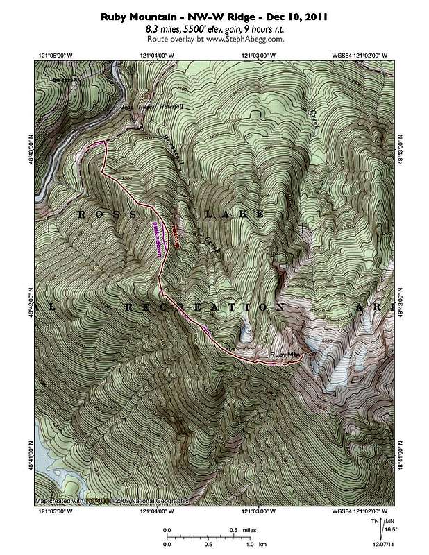
Route: Ruby Mountain - NW Ridge Route (North Cascades)

Mountain Information:

Driving Directions:

  • Trailhead: a turnout located across the highway from a large boulder field on the northwest side of Ruby Mountain (this is on HWY 20 about 12 miles east of Newhalem and 0.4 miles west of Horsetail Creek, at an elevation of about 1900’)
  • Co-ordinates: 48.7172, -121.0773
  • Address: Highway 20
  • Elevation: 1900 ft
  • Pass:  Northwest Forest Pass
  • Directions: summitpost: "1) Drive for approximately 12 miles east along Highway 20 to a small turnout (~1900' elevation). Park at one end of the turnout.
    NOTE: The turnout is 2.8 miles northeast of Colonial Creek Campground, and 0.4 miles west of Horsetail Creek, along Highway 20. The turnout is located across the highway from a large boulder field on the north side of Ruby Mountain.
    2) Steeply hike straight up the mountainside, starting left (east) of the large boulder field. Continue hiking straight up the hillside for approximately 450' elevation.
    3) After ascending 450' elevation from the highway, begin angling left for the next 200' elevation until reaching the northwest ridgeline.
    4) Follow the northwest ridge, crossing over Point 6315', until reaching the summit ridge. The final 300' elevation gain to attain the summit ridge and true summit requires scrambling. Here is a drive direction from google map.
  • Road condition
  • Weather forecast
  • Avalanche danger forecast:  

Route Information: NW ridge

Misc 

Sunday, April 23, 2017

Route: Mount St. Helens- Worm Flows Route (South Cascades)

Mountain Information:

Driving Directions:

  • Trailhead: Marble Mountain Sno Park
  • Co-ordinates: 46.1426, -122.1827
  • Address:Gifford Pinchot National Forest, NF-83, Cougar, WA 98616
  • Elevation: 2700 ft
  • Pass:  SnoPark Permit
  • Directions: Mount ST Helens Institute: "State Route 503, also known as Lewis River Road, closed on Monday, March 13, when a debris slide knocked trees and rocks down onto the highway near Speelyai Bay Road, about 21 miles east of Woodland in Cowlitz County. [WA Department of Transportation is] putting an emergency contract in place with Pacific Blasting to remove the slab and stabilize the hillside as soon as safely possible. While the debris on SR 503 may not look like much, it’s the instability of the slope above, including a massive rock slab, that has kept the highway closed.  DO NOT Attempt to access the trailhead via SR 503 from Woodland, WA. DO Access the trailhead via 503 from Battle Ground, WA."Here is a drive direction from google map.
  • Marble Mountain Sno-Park ski trails map
  • Weather forecast
  • Avalanche danger forecast:  

Route Information: NW ridge

Misc