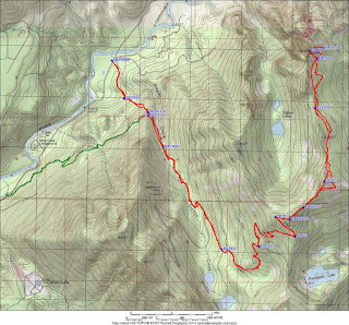
Route: Russian Butte (Middle fork Snoqualmie)
Mountain Information:
- Name: Russian Butte
- Region: Central Cascades (Middle fork Snoqualmie)
- Summit Elevation: 5123 ft / 1561 m
- SummitPost Link:
- Peakbagger Link:
- WTA Link:
Driving Directions:
- Trailhead: Shortcut Trailhead
- Co-ordinates: 47.4939, -121.6416
- Address: shortly before milepost 4.2 and the concrete bridge down the MF
road as described in this report.
- Elevation: 800ft
- Pass: Discover Pass
- Directions: "Take exit 34 off of I-90. Go north on 468th Ave for about 0.4 miles.
Go right onto SE Middle Fork Road. This TH is a couple of miles further down the MF
road than the traditional Granite Creek TH and cuts off about 3 miles
roundtrip--beautiful path to hike as well. Trail starts on the overgrown road to your right shortly before milepost 4.2 and the concrete bridge."
- Avalanche danger forecast:
Route Information: Revolution Peak
- Caltopo Route: https://caltopo.com/m/B5JS
- Route Description
- Summitpost: Hike as to Granite Lakes either from the Mailbox Peak parking lot or from the concrete bridge on the Middle Fork Snoqualmie. At 3 miles the trail forks right to the lakes but you should follow the left fork and old logging roads to the top of Thompson Point (5124). From here follow on or right of the ridgeline NE for 3.5 miles to Revolution Point. Then follow the ridge north for approximately 2 miles to 3rd class rocky slabs that lead to the summit. You might avoid the harder part of the slabs by ascending through steep forest on your left. RT 17.5 miles, approx 16 hours.
- Fred's book: Because of the relief and rugged terrain, the summit would be a trying adventure from the valley of the middle fork. A more feasible route would be to take Granite Creek Road and jeep trail from about 4 mi on Middle Fork Snoqualmie River Road, then hike cross-country to the saddle W of Thompson Lake (est. 4,250 ft). Hike N for 0.8 mi to Point 5124 on the ridge, then follow the crest NE for 0.6 mi to beyond Point 5454. Descend on the E slope and contour at about the 4,400 ft level; easy hiking leads nearly to the S summit in 1.25 mi. Bypass steeper terrain near this summit in 1.25 mi. Bypass steeper terrain near this summit at about 4,600 ft, then continue to the little saddle just S of the summit (a scrambling finish).


Misc
- Notes:
- Russian Butte doesn't get climbed very often, probably just a few time a year -despite its half hour proximity to Seattle it really is a remote peak with all the logistical challenges that go with that. It's not an easy peak to get to the top of, but if you do the rewards include adventure, exploration, views no one else gets to see and that odd feeling of being in the middle of nowhere in the middle of somewhere!
- Russian Butte can be climbed from the east route as described by the summitpost and this report.
- Russian Butte is a really cool collection of cliffs and spires and summits that guard the hanging valley containing Gifford Lakes 2000 feet below.


No comments:
Post a Comment