Mountain Information:
- Name: Vesper Peak
- Region: North Cascades (Mountain Loop Highway)
- Summit Elevation: 6214 ft / 1894 m
- SummitPost Link:
- Peakbagger Link:
- Mountaineers Links:
- Mountain Project Link:
- WTA Link:
Driving Directions:
- Trailhead: Sunrise Mine Trailhead
- Co-ordinates: 48.0295755,-121.5085599
- Address: Sunrise Mine Trailhead, NF-4065, Granite Falls, WA 98252
- Elevation: 2100 ft
- Pass: Northwest Forest Pass
- Directions
- SummitPost: "From
Seattle take I-5 North to Exit 194. Follow Highway 2 East for 2.3
miles, stay in left lane, go to Lake Stevens Highway 204 East, in 2.2
miles take left (north) on Highway 9 to Lake Stevens, in 1.7 miles take
right (east) on Highway 92 to Granite Falls, in 8.4 miles turn left
(north) to Mountain Loop Highway. Follow for about 30 miles to the
Sunrise Mine Road on the right. Road dead ends in about 1 mile where
parking is limited to one side of the road. Leave room for others to
turn around."
- Weather forecast
- Avalanche danger forecast:
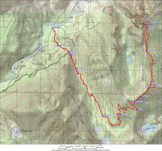
Route Information: Headless Pass
Misc
- Mountaineers trip reports
- CascadeClimbers trip reports
- Nwhikers.net trip reports
- Other Links:
- Notes:
- Stream crossings
- Good water flow at the Vesper Lake outlet creek
- While FS road 4065 is officially closed, it is passable all the way to the trailhead.
- Bring ice axes and micro-spikes. The first 3 or 4 inches of snow
was soft. However, there was an ice layer just beneath the soft snow.
Be prepared to kick steps the last 500ft of the ascent.
- The trail fades out as you enter the basin between Vesper and Sperry Peaks. Cross the outlet of the lake and follow an obvious talus ridgeline up to a col between the peaks. The climb is accessed by a ledge system that cuts across the north face of Vesper at about 5800 ft elevation and begins at a small notch overlooking the Vesper Glacier. Allow 3+ hours for the approach.
- Walk out the ledge on steep exposed heather (snow until mid-late summer?). When you can't walk any further either (A) scramble up over an obvious chockstone formed by a large, thin flake to a belay ledge or (B) as a variation backtrack a bit and figure out an exposed 3rd class traverse down and around the toe of a buttress before scrambling back up to an obvious and clean 5.6 layback crack (better start). The 3rd class slabs at mid-height on the first pitch could easily be accessed after climbing the lower half of the north face as well.
- Gear: Doubles of .5 - 1, singles of .2 - .4, 2, 3, and a set of small nuts. The route is protected by a mix of gear, bolts, and pins. Pitch 5 required the most gear, as it is very exposed, but takes gear well. Set up gear belays at the top of P1, P3. The rest of the pitches have fixed anchors for belays.
- This is the 5.7 variation that is on the eastern half of the North Face and the direct start begins at a large flake. Ragged Edges was retro-bolted in some places in August of 2013 and there are still some old pitons along the route. Generally done in 6 pitches.
Mountain Information:
- Name: Guye Peak
- Region: Central Cascades
- Summit Elevation: 5,168 ft / 1,575 m
- SummitPost:
- Peakbagger:
- WTA Link:
Driving Directions:
- Trailhead:
- Address: Alpental Access Rd, North Bend,, WA 98201
- Elevation: 2,950 ft
- Pass: Northwest Forest Pass
- Directions:
- SummitPost:
"Take I-90 from Seattle east to Snoqualmie Pass (30 - 45 minutes). Exit at Alpental Road and park at the Snoqualmie Ski Area, or use other public parking nearby."
- Mountain Project: "The route is located on the west face of Guye Peak. It begins at the top of the talus cone below the face, which is accessed by walking up through the houses on Ober Strasse Road."
- Road condition
- Weather forecast
- Avalanche danger forecast:
Route Information: Improbable Traverse / West Face
Misc
- Videos:
- Trip Reports:
- Mountaineers trip reports
- CascadeClimbers trip reports
- Nwhikers.net trip reports
- Notes:
- The west face of Guye Peak is easily visible from the interstate when driving from the west. With the exception of the traverse pitch, the rock is generally poor in quality and can be very lose.
- Approach: Start by hiking up the talus cone beneath the face and scramble a couple hundred feet of loose, mossy, dirty slabs to the the start of the roped climbing.
- Descent: From the summit traverse north up and over two subsummits. There is reputed to be a climbers trail descending from the Guye-Snoqualmie saddle, and descending to the west, but it was snowy when I was there so I never found it.
- Essential gears:
Mid-size rack: an assortment of 6-8 cams, small and mid-sized nuts including the small #3 nut for the anchor at the far end of the Improbable Traverse pitch.
60m rope (a 50m rope may not complete the Improbable Traverse Pitch all the way from Lunch Ledge; however, an intermediate belay can be done on the ledge leading to the crux moves) Helmet, Rock shoes, Approach shoes or boots
At least five double runners. A triple runner for the second protection point out from Lunch Ledge would be nice to mitigate rope-drag Sunscreen. The West Face receives the full bore of sun in the afternoon (on nice days). You may find yourself belaying at Lunch Ledge for a long time Trail Park Pass if parking a second car at Alpental.
- Be advised that the resort blasts to clear avalanche prone slopes during the day. Contact them at 425-434-7669 to find out if they will be blasting.
- The steep west face is climbed in the summer only. It offers several moderate to difficult alpine rock routes.
Mountain Information:
- Name: Columbia Peak
- Region: Central Cascades
- Summit Elevation: 7172 ft / 2186 m
- SummitPost:
- Peakbagger:
- WTA Link:
- Mountaineers Link:
- Mt Baker-Snoqualmie National Forest:
Driving Directions:
- Trailhead:
- Address: Monte Cristo Trail, Granite Falls, WA 98252
- Elevation: 2,360 ft
- Pass: Northwest Forest Pass
- Directions:
- SummitPost:
"Take the Mountain Loop Highway east from Granite Falls for 30.5 miles. When you get to the end of the pavement, you have found Barlow Pass. Parking can be found on both sides of the highway. The left fork of the road continues to Darrington, while the gated right fork leads to Monte Cristo in four miles."
- Road condition
- Weather forecast
- Avalanche danger forecast:
Route Information: West Ridge
- Approach & Ascend from Mountaineers:
- Mountain
bike or hike 4 mi from Barlow Pass to Monte Cristo (8 mi round trip,
500 ft elevation gain). From there hike the Poodle Dog Pass and Twin
Lakes Trails to the saddle at Twin Lakes.
- From the saddle,
ascend the west spur to the summit of Columbia Peak. From Monte Cristo,
this is 12 mi round trip and 4,400 ft of elevation gain.
Misc
- Videos:
- Trip Reports:
- WTA trip reports
- Mountaineers trip reports
- CascadeClimbers trip reports
- Nwhikers.net trip reports
- Notes:
- Silver Tip Peak/Southeast Ridge is a good Class 4 scrambling side trip from Poodle Dog Pass on the way to Twin Lakes and Columbia Peak.
- There are a number of camping possibilities on this route. Silver Lake would be a good camp, particularly if you wish to combine this climb with a Silvertip Peak climb. Twin Lakes are another potential camp, but this would add at least 600' additional elevation gain.
Mountain Information:
- Name: Bandera Mountain
- Region: Central Cascades (Snoqualmie Pass)
- Summit Elevation: 5241 ft / 1597 m
- SummitPost Link:
- Peakbagger Link:
- Mountaineers Link:
- WTA Link:
Driving Directions:
- Trailhead: Ira Spring Trailhead
- Directions
- WTA: "Take exit 45 off of I-90 and turn north onto FR 9030. A little over three quarters of a mile from the exit, stay left onto FR 9031. Follow it to its end and the trailhead for the Ira Spring Trail #1038. Road is one-lane gravel and dirt."
- Trailhead: Talapus Lake Trailhead
- Directions
- WTA: "From Seattle, head east on I-90 to exit 45. Turn left, and drive under the freeway on FR 9030. In 1 mile follow the road around to the right at a junction. Continue straight on a gravel, sometimes severely potholed road to the trailhead at the road's end. Northwest Forest Pass and Alpine Lakes Wilderness Permit required, both available at the trailhead."
- I-90 Road Condition:
- Weather forecast
- Avalanche danger forecast:
Route Information: Ridge Traverse
Misc
- Videos:
- Other Links:
- Notes:
- The bear grass section could have avalanche danger
- The route up to the false summit starts of very easy with the well grated Mason Lake Trail. This new trail goes past a beautiful waterfall and breaks out into the beautiful bear grass at about 4500 feet. There will be a spur trail (marked) that will go from there very steeply (but with good footing) up to the false summit of Bandera. Once on top of the false summit look for a boot path and then head down to the ridge up another false and then to the true summit of Bandera.
- As for times to the top of Bandera it will take you roughly between 1 to 2 hours to the false summit and 30 minutes or more to the true summit.
Mountain Information:
- Name: Russian Butte
- Region: Central Cascades (Middle fork Snoqualmie)
- Summit Elevation: 5123 ft / 1561 m
- SummitPost Link:
- Peakbagger Link:
- WTA Link:
Driving Directions:
- Trailhead: Shortcut Trailhead
- Co-ordinates: 47.4939, -121.6416
- Address: shortly before milepost 4.2 and the concrete bridge down the MF
road as described in this report.
- Elevation: 800ft
- Pass: Discover Pass
- Directions: "Take exit 34 off of I-90. Go north on 468th Ave for about 0.4 miles.
Go right onto SE Middle Fork Road. This TH is a couple of miles further down the MF
road than the traditional Granite Creek TH and cuts off about 3 miles
roundtrip--beautiful path to hike as well. Trail starts on the overgrown road to your right shortly before milepost 4.2 and the concrete bridge."
- Avalanche danger forecast:
Route Information: Revolution Peak
- Caltopo Route: https://caltopo.com/m/B5JS
- Route Description
- Summitpost: Hike as to Granite Lakes either from the Mailbox Peak parking lot or from the concrete bridge on the Middle Fork Snoqualmie. At 3 miles the trail forks right to the lakes but you should follow the left fork and old logging roads to the top of Thompson Point (5124). From here follow on or right of the ridgeline NE for 3.5 miles to Revolution Point. Then follow the ridge north for approximately 2 miles to 3rd class rocky slabs that lead to the summit. You might avoid the harder part of the slabs by ascending through steep forest on your left. RT 17.5 miles, approx 16 hours.
- Fred's book: Because of the relief and rugged terrain, the summit would be a trying adventure from the valley of the middle fork. A more feasible route would be to take Granite Creek Road and jeep trail from about 4 mi on Middle Fork Snoqualmie River Road, then hike cross-country to the saddle W of Thompson Lake (est. 4,250 ft). Hike N for 0.8 mi to Point 5124 on the ridge, then follow the crest NE for 0.6 mi to beyond Point 5454. Descend on the E slope and contour at about the 4,400 ft level; easy hiking leads nearly to the S summit in 1.25 mi. Bypass steeper terrain near this summit in 1.25 mi. Bypass steeper terrain near this summit at about 4,600 ft, then continue to the little saddle just S of the summit (a scrambling finish).


Misc
- Notes:
- Russian Butte doesn't get climbed very often, probably just a few time a year -despite its half hour proximity to Seattle it really is a remote peak with all the logistical challenges that go with that. It's not an easy peak to get to the top of, but if you do the rewards include adventure, exploration, views no one else gets to see and that odd feeling of being in the middle of nowhere in the middle of somewhere!
- Russian Butte can be climbed from the east route as described by the summitpost and this report.
- Russian Butte is a really cool collection of cliffs and spires and summits that guard the hanging valley containing Gifford Lakes 2000 feet below.
Mountain Information:
- Name: Treen Peak
- Region: Middle fork Snoqualmie
- Summit Elevation: 5763 ft / 1756 m
- SummitPost:
- Peakbagger:
- Mountaineers Link:
Driving Directions:
- Trailhead:
- Address: NF-5620, North Bend, WA 98045
- Elevation: 1,350 ft
- Pass: Northwest Forest Pass
- Directions:
- Mountaineers:
"From North Bend, drive the Middle Fork Snoqualmie River Road. Find a very faint miners/fishermans path on the north side of the road approximately 1.1 miles before the Dingford Creek Trailhead at an elevation of 1,350 ft."
- Avalanche danger forecast:
Route Information: Green Ridge


- Caltopo Route: https://caltopo.com/m/40EA
- Route Description
- Mountainers: On the USGS Snoqualmie Lake map look for elevation Point 1571. The path follows steeply northeast toward Green Ridge Lake. At about 4,100 ft where the track forks, continue north up the ridge (the other fork leads east to the lake). After gaining the ridge at 4,700 ft travel cross country northwest through open forest, heather meadows, and past a couple of tarns. After reaching Tarn 4662, proceed west to a boulder field and to Upper Garfield Mountain Lake. Camp at lake. Hike through timber north to Charlie Brown Lake. Above the lake at 4,800 ft reach a boulder field. Look for a gully northwest and enter at about 5,200 ft. It is very steep. Find forest at the top (~5,400 ft). Scramble north to the summit.
Misc
- Trip Reports:
- NWHikers trip report, June 21, 2008
- NWHikers trip report, July 14, 2008
- NWHikers trip report, June 23, 2006
- NWHikers trip report, Aug 13, 2002
- NWHikers trip report, Mar 25, 2009
- NWHikers trip report, Aug 10, 2008
- WTA trip report, Sept 30, 2006
- WTA trip report, Aug 13, 2002
- Green Ridge
- Notes:
- A strenuous scramble about 1.25 miles northeast of Mount Garfield with panoramic views of the Taylor River and several lakes in the Alpine Lakes Wilderness.
- The caltopo route is not a gps track and please don't rely on it for exact position and use your route finding skills instead.
- From this WTA trip report:
- This one starts along the upper MFK road at 1320'. Treen is a seldom visited peak that offers up a commanding vantage point to a less traveled area of the MFK Snoqualmie drainage.
- set off up the steep hill toward Green Ridge Lake making respectable time up the deliberate miners trail. crest the ridge at 4680' and then wander over a few bumps until come to Tarn 4662'. Here your target is in plain view just a ridgeline and lake basin away.
- wander across a grassy meadow to the west and then down a steep watercourse toward the upper Garfield Mountain Lake. Drop to 4300' where initiate a traverse counter-clockwise around the lake. Then end up having to drop to 4180' to avoid various cliff bands, but the route goes well enough.
- About midway across the main part of the upper Garfield Mountain Lake, trend up and to the north to avoid cliffs. Continue this ascending traverse all the way to Charlie Brown Lake (~4390') which offers up a good view of the route necessary to gain the summit of Treen.
- From Charlie Brown, Take to the SE slopes of the mountain working through various cliff bands and more duff slopes until come to a broad talus field at roughly 4850'. Here angle left up an obvious gully with some grassy slopes at its head. The gully take you to 5400' and immediately shot you out onto the more south facing slopes of the mountain.
- The last few hundred feet to the top were on easy, but steep heather slopes. Noteworthy views from the summit included those of Garfield, Big Snow Mountain, Dream Lake and the seemingly small Otter Slide.
- The trail up the ridge to Tarn 4662 does get faint in places once you pass the 3350' turn-off to Green Ridge Lake.
- Leaving from Tarn 4662 and dropping down to about 4400' and then taking the rockslide to the west seemed to be the best way to the upper Garfield Lake.
- Ascending NW on a boulder field from the lake and through a forest band to the 5000' contour seems to be the best route. Go left in the broad boulder field which gradually changes to talus and heather and then bear north up into a very steep gully. At the top of the gully, 5400', follow the trees and talus north to the summit.
- There are 1000 plus feet of counter elevation encountered on the return trip.


