Mountain Information:
- Name: Mount Price
- Region: Middle fork Snoqualmie
- Summit Elevation: 5587 ft / 1703 m
- SummitPost:
- Peakbagger:
- WTA Link:
- Mountaineers Link:
Driving Directions:
- Trailhead:
- Address: NF-5620, North Bend, WA 98045
- Elevation: 1,500 ft
- Pass: Northwest Forest Pass
- Directions:
- WTA:
"From Seattle, drive east on I-90 to exit 34. Turn left onto 468th Street and follow it to the junction with the Middle Fork Snoqualmie Road. Turn right and continue up the Middle Fork Snoqualmie Road for 12 miles to the large Middle Fork trailhead parking area on the right. Pass the parking area and turn right onto a gravel road immediately after crossing a large concrete bridge. The road is marked for Dingford and Dutch Miller Gap. Continue six miles on a heavily potholed road to a gate. Passes and privy are available at the trailhead."
- Avalanche danger forecast:
Route Information: Hester Lake Route (Summer Route)
- Caltopo Route: https://caltopo.com/m/F7LQ
- Route Description
- Mountainers: Hike the Dingford Creek trail 5.5 miles to Hester Lake. After passing the Myrtle Lake Trail, the trail is in poor shape. The trail is washed-out by the creek forking and destroying 0.2 miles of trail between 3,000-3,200 ft. The rerouted trail follows between the streams. Follow it on left side through brush until intersecting the trail or between the streams. The trail in early season has lots of water running down it. Continue cross-country through brush on the north side of the Hester lake to Little Hester lake, then gain the saddle northwest of Little Hester lake. Follow the ridge southerly to the summit. When snow is gone, the north ridge has one tricky move. It's 13 miles round trip with 4,100 feet of elevation gain.
- SummitPost:
- This route nearly circumnavigates the mountain. You start west of the peak, take a trail around the north side to the ENE side, then finish cross-country via the North Ridge. Views are not common for the first few miles. After that views are intermittent but the forest setting is quaint. The trail can be muddy in wet conditions. Hester Lake is pretty.
- Initially, the trail is very rocky like a dry streambed. It climbs steadily in a series of switchbacks before finally leveling off at about 2,400 ft. In about 1.5 miles the trail passes through a ravine with a picturesque slabby watercourse above. This is the creek draining Pumpkinseed Lake. In about 2.5 miles Goat Creek is reached. To the south across the valley is the cross-country Northwest Route to Mt. Price. The trail maintains a level grade for what seems like an eternity. In about 3.3 miles (2,850 ft) the trail to Myrtle Lake junctions off on the left. Stay to the right. In 3.7 miles the trail crosses the main fork of Dingford Creek. Look for a footbridge or wade the gravelly creek. The trail begins arcing southward up the Hester Lake drainage and finally begins to gain elevation. At 4.6 miles (3,350 ft) a small, swampy meadow is reached. The trail goes around the left (east) side and shortly begins switchbacking up the hillside before making a final traverse westward past two small ponds to the outlet of Hester Lake (3,886 ft). Six miles from the car.
- It may be possible to hike around the south side of the lake but the north side is probably easier, not to mention slightly shorter. Your next objective is Little Hester Lake (4,220 ft) nestled in a minor hanging basin west of the major lake. The terrain between the two lakes varies between talus, forest, and low-angle rock outcrops.Walk around the north side of Little Hester Lake bearing for the 4,640+ ft saddle to its northwest. The farther left you go on the ascent the shorter the distance to the summit but the rockier the terrain. We crested the ridge at about 4,800 ft almost due west of the lake. Our route involved a steepish gully (snow for us) but otherwise did not impede us. Once on the ridge (Price's North Ridge), simply follow it up the path of least resistance to the top. At first we stayed to the left (east) side but crossed over to the right side in the final couple hundred vertical feet to the top. The map shows the ridge being broad but it is sharper than that. Time: 4-6 hours depending on conditions; Distance: = 7.5-8.0 miles; Gain: 4,200 ft (some ups and downs)
- Descent A descent can be made the same way. Or, if you're feeling adventurous and you left no equipment at the lake, you could try and descend via the Northwest Route. That route is significantly shorter by distance and probably about an hour shorter in time.
Misc
- Videos:
- Trip Reports:
- Mountaineers trip report, Apr 1, 2017
- NWHikers trip report, Dec 29, 2013
- NWHikers trip report, Sept 28, 2011
- NWHikers trip report, Jan 09, 2011
- NWHikers trip report, May 14, 2005
- NWHikers trip report, Dec 17, 2004
- Peakbagger trip report, 2013-12-28
- WTA trip report, 2016-11-26
- WTA trip report, 2013-12-29
- WTA trip report, 2008-08-05
- SummitPost mount price photos
- Notes:
- In 2017, a log to cross Dingford Creek with care can be found slightly upstream from the Price Lake outflow confluence with Dingford Creek.
- Winter (snowy conditions): ice axe, ski poles, snowshoes, skis possibly (though it's a long haul for not much open terrain), cold weather clothing.
- There are three named lakes and a few other unnamed ones on the mountain's various slopes. The most notable of these is Hester Lake (3,886 ft) on Price's northeast side. The lake is actually quite large--over a half-mile in length and over 100 acres in size. A little further up the drainage is Little Hester Lake (4,220 ft). The last named lake is diminutive Price Lake (4,000 ft) northwest of the summit. This lake resides in a canyon that is suggestive of a geologic fault line. On a map, the creek draining the lake courses nearly due north all the way to the valley below.
- Take the Dingford Creek trail for ~2.2 miles to its crossing of Goat Creek (c. 2,600 ft). Leave the trail and cross the valley southward to gain the obvious basin rising up the other side. This is the basin in which Price Lake resides. Mt. Price's summit should be visible above (provided you can see it through the canopy). There are four cliffs bands to pass through--one at 2,800 ft, one at 3,200 ft, one at 3,600 ft, and a final one at c. 4,500 ft. With diligent map reading and on-site routefinding, all three can be negotiated. The slopes between these bands are easier. They could be talus or forest. It appears it would be best to stay east of the creek draining Price Lake.
- The Alpine Lakes Wilderness boundary runs along the East-West Mt. Price crest. Hence, the Southeast Route is not within the wilderness. The Northwest and Hester Lake routes are within the wilderness.
- Since the trailheads for this climb are fairly low (all below 2,000 ft), you could conceivably do the climb at any time of year. Winter ascents have been done. Winter and spring ascents will see brush covered by snow but the trail will be covered too, making things slower in that regard. Further, the trail tends to be muddy and boggy in rainy or snowmelt conditions.
- If you'd like to stay in the area (on the Dingford Creek side), then camping sites could be found even though there are no designated areas. If you can find open, flat ground, have at it. There is a moderately marshy area at 3,300 ft on the trail to Hester Lake (0.5 miles NNE of the lake). Camping at Hester Lake could be problematic because it's pretty rocky. This is rugged country. It is wilderness, after all.
Mountain Information:
- Name: Ingalls Peak
- Region: Central Cascades
- Summit Elevation: 7662 ft / 2335 m
- SummitPost:
- Peakbagger:
- WTA Link:
- Mountaineers Link:
- Okanogan-Wenatchee National Forest:
Driving Directions:
- Trailhead:
- Address: Cle Elum, WA 98922
- Elevation: 4,300 ft
- Pass: Northwest Forest Pass
- Direction: "Drive
on I-90 to about 1 mi east Cle Elum, then go northeast on SR 970 about 5
mi to 0.5 mi past the Teanaway River Bridge. Turn left on the Teanaway
River Road and continue 23 mi to the road end parking area at 4,243 ft,
about 1 mi beyond the DeRoux Campground (Forest Road 9737). Car camping
is available at the DeRoux Campground and other campgrounds on the
Teanaway River Road"
- Food
- Road condition
- Weather forecast
- Avalanche danger forecast:
Route Information: South Ridge
- Route Photos from trip reports:
Misc
- Videos:
- Trip Reports:
- Mountaineers trip reports
- WTA trip reports
- CascadeClimbers trip reports
- Nwhikers.net trip reports
- Notes:
- Protection: Normal rack to 2" with a set of nuts. Larger hexes work well in the serpentine cracks. Small rack to 2" and stoppers worked great. Slings are recommended as the route tends to zigzag. A 60M rope is required. Bring webbing as the rap anchors may need replacing at times. Standard rock equipment and chocks to 1.5 inches.
- Climbing is on generally good rock with moderate exposure.
- Rope leaders should have class 5 leading experience, as the red slab requires protection and has several tricky moves in the 5.2-5.3 range with a 5.6 variation, if desired.
- This climb is typically done as a one-day climb with a 6-7am start.
- This peak is best climbed in the summer months after the rock is snow-free and dryed. Once again be aware that the area is popular with campers and climbers alike. It is best done during the week.
- Camping is allowed in the area without permit but it is located in the Alpine Lakes Wilderness Area, so wilderness rules apply. Camping is not allowed at Ingalls Lake. There are designated campsites along the main trail on the way up to the lake.
Mountain Information:
- Name: Mount Garfield
- Region: Middle fork Snoqualmie
- Summit Elevation: 5,519 ft / 1,682 m
- SummitPost:
- Peakbagger:
- WTA Link:
- Mountaineers Link:
Driving Directions:
- Trailhead:
- Address: NF-5620, Baring, WA 98224

- Elevation: 1,174 ft
- Pass: Northwest Forest Pass
- Directions:
- SummitPost:
"From Interstate 90, take Exit 34 (34 miles east of Seattle) near North
Bend. Drive north off the freeway past a truck stop on the left. At
the T-junction about 0.5 miles from the freeway take a right onto Lake
Dorothy Road. Continue east on this road. It becomes Middle Fork
Snoqualmie River Road (FR-56) in a few miles. It is paved for a while
then goes to good gravel (recently regraded). At some point on the road
you will see your quarry looming in the distance. Then the forest
canopy hems in your views. At 14 miles you will come to the Taylor
River Road junction. Continue for 2.6 miles past two switchbacks to the
trailhead, which is located at a wide gravel wash that you have to
descend a few feet to get into. You may also know it by the redneck
paraphernalia littered about: old TVs, old CDs used as skeet targets,
milk jugs on sticks, and bullet casings on the ground.."
- Trip Report: "The trailhead is about 1 hour from Seattle. To get there, leave I-90 at Exit 34 (East of North Bend) and turn East on Edgewick Road. Follow this road 0.4 miles to a stop sign, then turn right on SE Middle Fork Road, which becomes Forest Service Road no. 56. Drive 12.3 miles to the Middle Fork-Taylor River road junction which is just after the Taylor River bridge. Turn Right onto no. 5620 and drive 1 mile to a 5-car pulloff. The trailhead is 100-200 yds further down the road on the left. Hike steeply uphill to the base of the route, 30 minutes if fast. Now, just look for bolts"
- Avalanche danger forecast:
Route Information: Mount Garfield / Infinite Bliss
Misc
- Videos:
- Trip Reports:
- Mt. Garfield, South Route August 19, 2001
- Mt. Garfield - Infinite Bliss May 14th, 2004
- Mt. Garfield Infinite Bliss June 12, 2009
- NWHikers.net: Infinite Bliss Sep 10, 2011
- NWHikers.net: Garfield Mountain, South Route - August 27-28, 2011
- CascadeClimbers: Mount garfield - Infinite bliss 07/19/2015
- CascadeClimbers: Mt. Garfield - Infinite Bliss 07/04/2013
- CascadeClimbers: Mt. Garfield - Infinite Bliss 07/16/2013
- CascadeClimbers: Mt. Garfield - Infinite Bliss 06/15/2012
- CascadeClimbers: Mt. Garfield - Infinite Bliss 05/13/2011
- CascadeClimbers: Mt. Garfield - Infinite Bliss 08/02/2010
- CascadeClimbers: Mt. Garfield - Infinite Bliss 07/14/2010
- CascadeClimbers: Mt. Garfield - Infinite Bliss 08/18/2007
- CascadeClimbers: Mt. Garfield - Infinite Bliss 07/15/2005
- CascadeClimbers: Mt. Garfield - Infinite Bliss 05/01/2004
- Fall on Rock, Failure of Nut and Piton, Washington, Mount Garfield
- Notes:
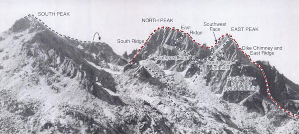
- There are actually five separate peaks on the Garfield Mountain massif
and several lesser crags. Every single one of these peaks requires
technical climbing to conquer. The West Peak (4896F, 336P) is 0.9 miles
away. It's most notable feature is a 20+ pitch sport route bolted onto
the slabs of a southside gully/amphitheater. This sport route is
called "Infinite Bliss" and has been spotlighted in several climbing
magazines. I reserve no judgment here on the permissibility of this
'bolted' route within the Alpine Lakes Wilderness, in which the Garfield
Mountain massif resides. The East Peak (5480+F, 520P) is 0.4 miles
away. A worthy objective unto itself, it is largely forgotten. The
North Peak (5101F, 301P) is 0.5 miles away. The last peak and perhaps
the most astonishing is just west of the Main Peak. It is called
Leaning Spire (5040+F, 120P) and it really does lean and it really is a
spire. Its east face rises incredibly above the notch separating it from
the Main Peak. Two of the lesser crags are Courte-Echelle, the next
large tower to the east of the Main Peak, and Little Flat Top, a small
horn in between the two. Outrigger Spire (4960+F, 240P) is located
north of the East Peak.
- Infinite Bliss, a 23 pitch bolted climb (crux 10c) on Mt. Garfield's
West Peak. This impressively long route climbs roughly 2600 vertical
feet, and is claimed to be the longest "sport" climb in North America.
- You would typically set out to climb Garfield Mountain as a day-trip but
with the understanding that you may be forced into an impromptu bivy.
There are several flat spots on route that could accommodate you. Other
than that, there are no designated bivy sites. Of particular note, the
base of No. 1 Gully may still have a small trickle of running water in
late August.
- Details from mountainproject.
- This route is not a sport climb. It is a bolt-protected slab climb, and it is extremely long which means you need to be quick and efficient. In fact, it's quite possible it's the longest bolted climb in the USA and Canada and the second longest in North America. There are sections where runouts can top 100 feet with little to no options for trad gear. However, any move harder than 5.6 is well protected, and the crux pitches are fully-bolted sport pitches.
- The "parking lot" and approach is at N47.54604, W121.52151, Elevation: 1174'. Simply copy and paste the GPS coordinates, excluding the elevation, into Google Maps and it will tell you how to get there. From the parking lot, the approach is about 45 minutes long and is mostly uphill through switchbacks in the forest. While the trail was not explicitly marked when I climbed the route, it is worn enough that if you are hiking more than a few minutes and it does not look like you are on a trail, you are off route.
- Pitches 1 - 7: These pitches involves easy, low-angle, somewhat runout climbing on solid slab. The rock can be a bit water-polished. Be careful if there are parties above you because if they knock rock down the rock will blast right through the first six pitches at triple digit speeds. Numerous bent hangers on these pitches are obvious indicators of the rock fall hazard. If you are confident simulclimbing 5.8, the first six pitches are the place to do it.
- Pitches 8 - 12: The rock starts to steepen here, but the pitches become more closely bolted as the moves get harder.
- Pitches 13 - 18: Mostly easy climbing. The most runout section is in here. Be very careful not to knock loose rock down on climbers below as the rock quality in this section is fair in some areas. Dont feel bad if you dont find the bolts on P15 as I missed both of them. P16 and 17 have no pro aside from the belay station. The climbing is very easy, but the rock quality is fair and the rock tends to be slightly polished, so be careful.
- Pitches 19 - 23: These are the hardest pitches, but they are mostly sport-bolted pitches. Both of the 5.10 pitches are well bolted.
- WARNING: Rock fall is a serious concern here. Wear a helmet, and once you pass pitch six, be extremely careful not to knock loose rock down on other climbers. The entire route follows a gully slab, and if you knock rock down it will have nowhere to go but right along the route the entire way.
- Protection: Seventeen quickdraws or 30 if you plan to simulclimb. Bring 2' trad draws as you will get a bunch of drag using only sport climbing draws. You do need two 60m ropes. A 70m or 80m is not long enough. I did not see many worthwhile trad placements when I climbed it as the route is mostly slab. If you really want to bring trad gear, bring a set of nuts, but don’t plan to do much with them.
- It is "R" rated because you literally climb 200 feet without a bolt over super chossy although easy terrain. Every move harder than 5.7 is well protected.
- Like many other people we got lost in the chossy section. The intermediate anchor is directly above the first bush WITH slings (80'). It isn't visible from any direction until you're about 15 feet away. From the anchor below the choss to the intermediate is > 200'.
- Climbing this route with parties above/below is extremely unnerving. On Saturday we saw several golfball-to-softball sized shrapnel pieces come down, and on Sunday we couldn't avoid causing the same, especially over the P15-17 chossfest, both ascending and descending. These pitches are very different from other alpine choss I've climbed: it's a low angle continuous slab, with no blockiness or ledges to halt a major fall, and every hold is suspect, for at least these 400 feet.
- Why there's no anchor other than the bush between the current P16 and P15 stations is beyond me, it's currently basically impossible to ascend or descend the route without unroping or "simuling with a death pact" -- no gear between. It's very psychologically taxing to climb these two pitches, both on the way up and down, and honestly felt like the crux of the route. Dealing with the double ropes on the chossy low angle rap was a lot of work at a very tired state.
- The climbing is not that hard, and all the hard pitches, rated 10b, 10c, 10a, are tightly bolted enough that pulling on draws can easily get you up at a 5.9 A0 grade. Our ascent of the 10c pitch was definitely a case of reverting to 5.9 A0 after so much climbing. This route would be 4-stars if it wasn't for the P15-17 choss. The climbing on the rest of the route is fantastic!
- Pitches 2 and 3 add up to 250' - rapping them with 2x70 left us 20' short (easy but exposed down-scramble). In general, the route appears slightly longer than the indicated 2600'. My GPS (barometric altimeter) indicated 2550' elevation change on rappel, so, given the ~45 degree angle of at least 40% of the route, and some zig-zag here and there, I'd estimate the route to be between 2800' and 3000'. We were, however, able to combine the following rappels just fine with 2x70: 23+22, 20+19, 12+11, 5+4. The 23+22 looked like it would *almost* go with 2x60 (didn't pay attention to how much rope remained on the other ones).
- Route starts 47.549,-121.5137. The trail has at least 3 branches:
- a flat horizontal traverse (good trail) that takes you to the slab too early (too low)
- an up-and-down traverse (also good trail) that takes you to the route
- a branch that continues uphill much higher than the start of the route
- So turn left to get to the route, but take the 2nd left rather than the 1st one. If you have a GPS, longitude 121.5137 is your target (the main trail in the forest goes mostly east-west, the traverses to the slab go north-south). Elevation gain from the road to the start of the route is right about 1000 feet.
- Be aware that mosquitos will follow you up the rock for quite a way if you're climbing in June, or any hot month. Don't bivy at the base for a quick start. The road is nearby and your car is more comfortable. It's only a 45 minute approach anyways, so just wake up earlier, and avoid doing what I've done.
- Bring lots of water, obviously.
- The chimney pitch can seep so having an addition large cams can be helpful.
- Route was in good shape on 3 Oct 2017.