Mountain Information:
- Name: Ruby Mountain
- Region: North Cascades
- Summit Elevation: 7408 ft / 2258 m
- SummitPost Link:
- http://www.summitpost.org/ruby-mountain/552394
- http://www.summitpost.org/ruby-mountain-nw-w-ridge/765118
- Peakbagger Link:
- WTA Link:
- Mountaineers Link:
Driving Directions:
- Trailhead: a turnout located across the highway from a large boulder field on the northwest side of Ruby Mountain (this is on HWY 20 about 12 miles east of Newhalem and 0.4 miles west of Horsetail Creek, at an elevation of about 1900’)
- Co-ordinates: 48.7172, -121.0773
- Address: Highway 20
- Elevation: 1900 ft
- Pass: Northwest Forest Pass
- Directions: summitpost: "1) Drive for approximately 12 miles east along Highway 20 to a small turnout (~1900' elevation). Park at one end of the turnout.
NOTE: The turnout is 2.8 miles northeast of Colonial Creek Campground, and 0.4 miles west of Horsetail Creek, along Highway 20. The turnout is located across the highway from a large boulder field on the north side of Ruby Mountain.
2) Steeply hike straight up the mountainside, starting left (east) of the large boulder field. Continue hiking straight up the hillside for approximately 450' elevation.
3) After ascending 450' elevation from the highway, begin angling left for the next 200' elevation until reaching the northwest ridgeline.
4) Follow the northwest ridge, crossing over Point 6315', until reaching the summit ridge. The final 300' elevation gain to attain the summit ridge and true summit requires scrambling." Here is a drive direction from google map. - Road condition
- Weather forecast
- Avalanche danger forecast:
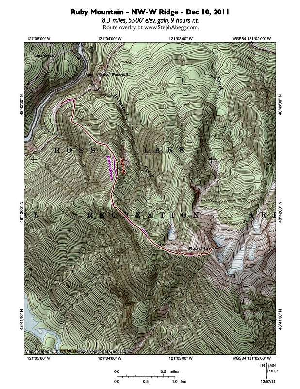
Route Information: NW ridge
- Gain: 5,600 ft
- Round Trip: 9 miles
- Difficulty: Winter Scramble
- Season: Winter, Spring, Summer, Fall
- Source: https://www.mountaineers.org/explore/activities/winter-scramble-ruby-mountain-winter-2
- Existing tracks:
- Related Trip Report: http://www.stephabegg.com/home/tripreports/washington/northcascades/ruby
- Caltopo Route: https://caltopo.com/m/5MQ9
Misc
- Videos (many more on youtube):
- Other Links:
- Ruby Mountain - North side 05/07/2018
- Ruby Mountain, Happy Creek Route. March 20, 2018
- Mountaineers Trip report May 4, 2015
- Flickr photos May 1, 2011
- nwhikers.net trip report 07-28-2011
- nwhikers.net trip report 12-11-2011
- nwhikers.net trip report 01-25-2017
- yellowleaf trip report 12-10-2011
- Ruby Mountain - May 13, 2016
- skagitalpineclub.com trip report January 31, 2011
- Notes:
- The summer route is on the south ridge as described in wta.org (RT 17 miles, gain 6300 ft)
- The parking place is described by this report as: "We parked at a turnout located across the highway from a large boulder field on the northwest side of Ruby Mountain (this is on HWY 20 about 12 miles east of Newhalem and 0.4 miles west of Horsetail Creek, at an elevation of about 1900’). This start of the climb is also only shortly before the winter closure gate at MP 134, making Ruby one of the last accessible climbs along HWY 20 in the snowy season."
- There are snow and cliff bands along the ride and final exposed scramble as described by this report:
- The NW Ridge route starts just left of the large boulder field. We began hiking straight up the timbered ridge. The route is straightforward, and we were able to navigate cliff bands via snow ramps. We put on snowshoes at about 4000', took them off a few minutes later to negotiate a cliffy area, and then put them back on. After a few hours we popped up onto Point 6315, and from there headed up the open ridge to the summit. The snow on this open ridge was composed of a crust that would hold your weight for a split-second, then break and drop you into a layer of cold powder that would flow under your feet.
- Between 12:13 and 12:45 pm, all of us summited except Bodie, who was left anchored to a tree, deemed too rambunctious to handle the final scramble over exposed mixed rock and snow to the summit. The 7,408-ft summit of Ruby Mountain is open with a unique views looking directly down onto Ross Lake, as well as far-ranging 360-degree views of other peaks in the North Cascades National Park. There is also an antenna/repeater station on the summit
- The vertical mile of descent was long and tedious, but we made it out just before dark
- Topo maps: calTopo map.